Theory to Reality
These figures best match the costs and models of economic theory. But the beauty of a local congestion charge is that we can look more closely at our city and decide where the priorities and pitfalls lie. For example, the system outlined above would hand an advantage to the Naburn Designer Outlet over the Clifton Moor or Monks Cross shopping centres, as drivers from outside of York would not be charged for visiting the Naburn site. Include it, and we can hand an advantage to smaller neighbourhood centres over the out-of-town centres and the city centre itself. Encouraging regeneration of neighbourhood commerce this way would also help reduce demand for travel.
Some of the most congested areas(1) in the city are on the inner ring road. These would therefore have to be included in the inner zone also. Otherwise, they would worsen further as residents shunned the outer ring road to avoid being charged to return to the city.
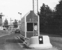 Charging during peak hours only would have the effect of spreading the peak traffic through a longer portion of the day. It would be better to charge lower tolls for longer. Collecting charges is not a complicated matter: vouchers could be sold in shops(2), and payment by internet or mobile phone accepted. Such a system is used in London. Booths just outside the zone (such as the one in Oslo, right) could even be used as a transitional measure. Charging during peak hours only would have the effect of spreading the peak traffic through a longer portion of the day. It would be better to charge lower tolls for longer. Collecting charges is not a complicated matter: vouchers could be sold in shops(2), and payment by internet or mobile phone accepted. Such a system is used in London. Booths just outside the zone (such as the one in Oslo, right) could even be used as a transitional measure.
The recent Local Transport Plan(3) aims to cut peak traffic by 3% by 2010. In comparison, the 2002 study(4) predicted up to a 5% cut in peak traffic levels using the baseline charges given. However the study also showed that for York, traffic levels would continue to decrease as the charge increased. Whilst that might seem obvious it actually depends on what alternative routes are available to avoid the charge.
In short, if a shift away from private transport to an ever-improving public transport system were to be a political aim(5), a congestion charge would be the most effective way of achieving this.
Notes and References
1.
The most congested areas in York are the well-known pollution hotspots of Gillygate, the Fishergate gyratory, the Nunnery Lane/Prices Lane gyratory, Lawrence Street and Holgate Road (see the City of York Council's Air Quality Factfile for more information). Not all of these locations are suitable for inclusion within the inner zone being discussed, and most will be sufficiently affected by the inclusion within the inner zone of the final destinations that they serve. However there is an argument for including roads around the hotspots which form destinations in themselves - such as Lord Mayor's Walk to Jewbury, serving the retail centre at Foss Islands Road and the very congested Gillygate, and Prices Lane, serving St. George's Field Car Park and the very congested Castle Mills Bridge.
Clearly, if the political will was behind the scheme, there would have to be a detailed expert study performed locally looking at these questions.
2.
This sort of payment model was used for the FTR project, First Group's 'new way to travel', which combines a new bus design with a set of infrastructure upgrades. The StreetCar, produced by the Wright Group, is an articulated bus with a well-designed interior mimicking that of the modern trams running in places like Manchester and Sheffield. The ticketing arrangement are part of the FTR package, which also includes real-time bus information at stops and bus priority measures at traffic lights. Unfortunately the one payment method that was neglected was on-board payment, the one most commonly used in all known UK bus services. The project was also associated with fare rises, and met with a rough initial reaction (see the Wikipedia article).
3.
See the Local Transport plan 2006-2011. Most of its demand management strategy consists of 'soft' public transport provision measures which can only be loosely described as demand management. 'Low Emission Zones' (priority for public transport and 'greener' vehicles) are mentioned in passing, but the policy in the end is explicit in its approach: congestion will be tackled by investing heavily to improve access to the city centre for public transport and greener vehicles (pt 1, page 7). It is discouraging, for example, to read the aim of "junction improvements on the York Outer Ring Road to reduce congestion on this key route as well as the city centre" (also pt1, pg. 7). Targets for traffic reduction are in part 4, page 203.
4.
See Double Cordons in Urban Areas to Increase Social Welfare (Santos, 2002), table 2, page 14. Depending on the elasticity of demand, the number of trips made during peak times drop by between 2% and 4.9%, with travel times reduced by between 5.1% and 6.4%. It must be remembered, however, that this study is concerned with the maximisation of social welfare, as calculated according to economic theory, rather than with the aim of reducing demand for road space.
5.
It is my personal view that this must be a political aim: There is so much uncertainty regarding environmental economics, especailly with regard to climate change, that politicians must at the end of the day decide this on the grounds of political principle. Road pricing should be set at a level to achieve this aim, rather than at a level to mirror externalities. Determining the latter is a neverending economic academic exercise, whereas the former depends on measurable results.
|